Railroads & Locomotives Maps Southeastern Power Plants

Southeastern Power Plants

By Angela Cotey | January 18, 2010

| Last updated on March 17, 2021

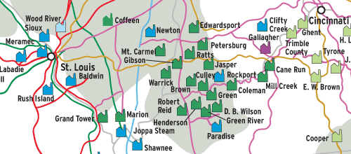
Coal is the biggest rail-carried commodity. This map shows where it is consumed in the Southeast in relation to railroad main lines.

Email Newsletter

Get the newest photos, videos, stories, and more from Trains.com brands. Sign-up for email today!

Map of southeastern power plants
Robert Wegner

This Map of the Month appeared in the January 2003 issue of Trains magazine.

This is the second in our series of coal-fired power plant maps of the U.S. The first, showing the Northeastern quadrant of the U.S., appeared in June 2002 Trains.

Electrical generation in the South obeys a much different pattern than in the Northeast. Coal is not readily available, but natural gas and fuel oil are plentiful and cheap, so they are the fuels of choice. The South is wetter, so water power in major rivers is more important. Industrialization and population growth came to the population growth came to the South later, during and after World War II, so power plants tend to be very large and of recent construction. The advent of air-conditioning, also after the war, created a huge demand for electricity.

Most coal burned in the South must be imported from elsewhere, which has major implications for railroads. Only Texas and Alabama have large coal deposits, but it’s either too expensive (Alabama) or too poor in quality (Texas) to suffice entirely. Major U.S. sources to the South are eastern Kentucky and West Virginia, via CSX and NS; Wyoming’s Powder River Basin, via BNSF and UP with some interline movements to CSX, KCS, and NS, plus rail/barge; and the Illinois Basin, mostly by barge via the Mississippi River and the Intracoastal Waterway.

Rapidly rising in importance is foreign coal, particularly from Columbia to Florida and Alabama. In 2001, imports amounted to 19.7 million tons, or about 1500 unit trains’ worth. Coal imports to the U.S. will probably reach parity with exports within a few years.

Long rail moves of coal are predictable, profitable, and simple to manage: foreign coal competition is a major threat to railroads.

Railroads included in this map:
BNSF Railway; Canadian National; CSX Transportation; Kansas City Southern; Norfolk Southern; Union Pacific

Download the map
Success, start your free download!
Download the map PDF
You must login to submit a comment