Railroads & Locomotives Maps Evolution of Canada’s grain network

Evolution of Canada’s grain network

By Angela Cotey | March 24, 2010

| Last updated on March 17, 2021

From a 1935 peak of nearly 20,000 miles, Canada's grain-gathering rail lines have evolved.

Email Newsletter

Get the newest photos, videos, stories, and more from Trains.com brands. Sign-up for email today!

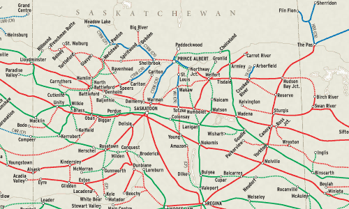
Evolution of canada’s grain network image

Three distinct periods of railway construction created the grain-gathering network that served the farmers of Manitoba, Saskatchewan, and Alberta.

The first 3,000 miles were built between 1881 and the onset of a depression in 1893. Better times returned in 1896, fueling an incredible boom that saw the construction of more than 11,000 route- miles by the Canadian Northern, Grand Trunk Pacific, Canadian Pacific, and others. World War I ended the proliferation of new lines and led to Canadian National’s takeover of both the Canadian Northern and Grand Trunk Pacific. Intense rivalry between CN and CP prompted the third boom in grain branches, with 4,500 miles built between 1918 and 1935.

This map shows the evolution of lines in place by 1941, when the rural railway network comprised more than 19,500 miles, serving over 5,000 elevators at more than 2,000 delivery points. (The few lines built after 1941, mainly to serve mines or gas plants, are not shown.)

Intense political pressure ensured that few miles would be abandoned. Yet by 1975, the grain-handling trackage had deteriorated so badly that even organizations usually violently opposed to rail removal conceded that some lines had to come up. Two exhaustive studies in the 1970s recommended the removal of 3,129 miles of branch lines. The 1983 abolition of the “Crow Rate,” which pegged grain-shipping charges at 1897 levels, led to more rail abandonment.

By 2005, some 6,600 miles – 35 percent of the region’s peak mileage – had been abandoned. Another 2,500 miles (13 percent) had been spun off into regional railways. Other lines have not seen the passage of a train for months or even years; for some, abandonment has already begun. (The authors would like to thank Ed Greenberg, manager of public affairs for Canadian Pacific, for his help.)

Railroads included in this map:
Athabasca Northern; Alberta Prairie; Canadian National; Canadian Pacific; Carlton Trail; Central Manitoba; Central Western; Fife Lake; Great Western; Greater Winnipeg Water District; Hudson Bay; Lakeland & Waterways; Mackenzie Northern; Northern Alberta; Red Coat Road & Trail; Savage Alberta; Southern Manitoba; Southern Rails Cooperative; Thunder Rail; Wheatland Railway

Download the map
Success, start your free download!
Download the map PDF
You must login to submit a comment