Railroads & Locomotives Maps New Haven Railroad passenger/freight density, 1955

New Haven Railroad passenger/freight density, 1955

By Angela Cotey | March 22, 2010

| Last updated on March 17, 2021

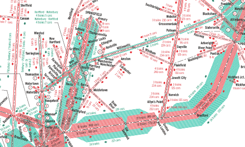
The passenger and freight transportation machine that was the New York, New Haven & Hartford in the mid 1950s.

Email Newsletter

Get the newest photos, videos, stories, and more from Trains.com brands. Sign-up for email today!

New Haven traffic map thumbnail

The New Haven’s heavy passenger orientation is obvious, especially on the New York-Boston Shore Line. On the electrified West End, torrents of commuters flowed in and out of New York’s Grand Central Terminal. Some intercity runs used GCT too, while a relative handful of trains bound to and from points west of New York used Penn Station via the Hell Gate Bridge route. Commuters also accounted for much of the density in and out of Boston’s South Station. The figures reveal a number of one- and two-car trains on the Boston-area branches — ideal for NH’s fleet of self-propelled Rail Diesel Cars.

NH was southern New England’s freight backbone, as well. Western connections fed trains to Maybrook, N.Y., and carfloats to Bay Ridge, located on New York Harbor. Though seemingly robust, NH freight was in steep decline, thanks to highway construction and changes in New England’s economy. For a look at the NH in words and photos, see J.W. Swanberg’s article in the “Fallen Flags Remembered” section of the Spring 2002 Classic Trains Magazine.

Railroads included in this map:
New York, New Haven & Hartford

Download the map
Success, start your free download!
Download the map PDF
You must login to submit a comment