Railroads & Locomotives Maps Wisconsin’s railroads in 1940 and 2005

Wisconsin’s railroads in 1940 and 2005

By Angela Cotey | March 24, 2010

| Last updated on November 3, 2020

In Trains' 65 years, our state's rail network has shrunk drastically.

Email Newsletter

Get the newest photos, videos, stories, and more from Trains.com brands. Sign-up for email today!

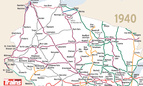
Wisconsin railroads in 1940 map image
Wisconsin railroads in 2005 map image
When Al Kalmbach published the first issue of Trains in November 1940, the company’s home state of Wisconsin boasted 6,675 route-miles of railroad, a total that had peaked at 7,500 two decades earlier and was declining. Lingering effects from the Great Depression kept the state’s three largest railroads in bankruptcy — Chicago & North Western, Milwaukee Road, and Soo Line were all operating under court-appointed trustees in 1940.

North Western was the state’s dominant railroad. With affiliate Omaha Road, C&NW served every corner of Wisconsin, often with duplicate routes. Competition came from the Milwaukee, which blanketed the southern half of the state, and Soo Line in the north. Despite extensive branches, all three roads carried their heaviest traffic between Chicago and Minneapolis-St. Paul on routes that are maintained to this day. The branches and low-density through routes have mostly disappeared.

Milwaukee Road’s 1977 bankruptcy triggered some surprising shifts in rail ownership. Soo Line acquired the Milwaukee in 1985, then spun off its historic Wisconsin trackage to the newly formed Wisconsin Central in 1987. Canadian National purchased WC in 2001 and now can claim just under 50 percent of all rail mileage in the state, while the former Milwaukee Road main line linking Chicago and St. Paul has become a key link in Canadian Pacific’s network. Chicago & North Western had a decades-long practice of abandoning or spinning off Wisconsin lines; C&NW had more than 2,500 miles in 1940, while successor Union Pacific in 2005 operates just 650 Wisconsin miles, one-quarter on trackage rights. Meanwhile, the Burlington’s line along the Mississippi River, a passenger-heavy route in 1940, today under BNSF is the state’s most heavily used main line, and is all-freight.

More than 95 percent of Wisconsin’s rail mileage had passenger service in 1940, with just under 1,000 stops and frequencies ranging from two trains a day in rural areas to 50 a day in Milwaukee, the largest city. Wisconsin now has nine stations, eight served by Amtrak (the Chicago-Milwaukee Hiawatha corridor and the Empire Builder), plus Kenosha, the end of Metra’s UP North commuter line from Chicago.

Railroads included in this map:
Ahnapee & Western; BNSF Railway; Camp 5; Canadian National; Canadian Pacific; Chicago & North Western; Chicago, Burlington & Quincy; Chicago, Milwaukee, St. Paul & Pacific; Chicago, St. Paul, Minneapolis & Omaha; Duluth, Missabe & Iron Range; Duluth, South Shore & Atlantic; East Troy; Escanaba & Lake Superior; Great Northern; Green Bay & Western; Hillsboro & Northeastern; Illinois Central; Iowa, Chicago & Eastern; Laona & Northern; Marinette, Tomahawk & Western; Mid-Continent Railway Museum; Northern Pacific; Progressive Rail; Soo Line; Tomahawk; Union Pacific; Wisconsin Great Northern; Wisconsin Northern; Wisconsin & Southern

Download the maps

2 thoughts on “Wisconsin’s railroads in 1940 and 2005

You must login to submit a comment