Railroads & Locomotives Maps Great Lakes ports in 2003

Great Lakes ports in 2003

By Angela Cotey | April 10, 2012

| Last updated on March 16, 2021

Get our weekly newsletter delivered to your inbox

Email Newsletter

Get the newest photos, videos, stories, and more from Trains.com brands. Sign-up for email today!

TM0304

Commercial shipping on the Great Lakes follows a 2,300-mile corridor from the St. Lawrence Seaway to the western edge of Lake Superior. Over 200 million tons of cargo a year cross the five lakes and connecting waterways, hauled in some 150 U.S. and Canadian lakers, 50,000 barges, and about 1,000 visits by ocean-going vessels, or “salties.”

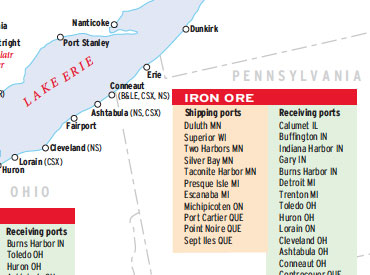
Traffic is dominated by three bulk commodities: iron ore (mostly taconite pellets), coal, and limestone. Iron ore alone comprised 37 percent of the tonnage handled by U.S. Great Lake ports in 2003, followed by coal (22 percent); limestone (16 percent); grain and farm products (4 percent); gypsum, sand and gravel (4 percent); and cement (4 percent).

Railroads haul most of the coal, iron ore, and grain to lakeside. Most bulk commodities load at ports on Lake Superior and the northern half of Lake Huron for delivery to cities and industries along the southern lip of Lake Michigan, the channels between Lake Huron and Lake Erie, and the shores of Lake Erie. Containers are largely absent from the Great Lakes trade.

Duluth-Superior ranks number one in tonnage and leads all Great Lake ports in outbound shipments of iron ore, coal, and U.S. grain products. (Thunder Bay is tops overall for grain.) Eighty percent of Duluth-Superior’s outgoing port traffic arrives by rail — all of the coal and iron ore and 70 percent of the grain. Four to five trains a day of Powder River Basin coal unload there, bound for U.S. and Canadian power plants along the Great Lakes. Iron ore heads to steel mills near Detroit, Chicago, Conneaut, and Hamilton.

Eastern railroads still haul Appalachian coal to Ohio piers Ashtabula, Conneaut, Toledo, and Sandusky, but now most is bound for Canadian ports, not U.S.

A fleet of 13 thousand-foot self-unloaders carry most of the iron ore and coal from Lake Superior. With capacities of 60,000-80,000 tons, they carry the equivalent of four coal trains. They’re captive to the Great Lakes because they can’t fit through the Welland Canal. Salties, many of which haul foreign steel inbound and grain outbound, are limited to 740 feet in length by locks in the St. Lawrence Seaway.

While rail moves year-round, the Great Lakes shipping season runs from April through early January.

Railroads included in this map:
Arnaud;  Belt Railway of Chicago;  Bessemer & Lake Erie;  BNSF Railway;  Canadian National;  Canadian Pacific;  Cartier;  Central Michigan;  Chicago Rail Link;  Chicago South Shore & South Bend;  Conrail;  CSX Transportation;  Duluth, Missabe & Iron Range;  Essex Terminal;  Lake Superior & Ishpeming;  Norfolk Southern;  Northshore Mining;  Oglebay Norton;  Quebec North Shore & Labrador;  Union Pacific

Success, start your free download!
Download the map PDF
You must login to submit a comment