


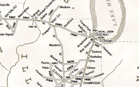
This Map of the Month appeared in the October 2007 issue of Trains magazine.
Like other great American railroads, the Illinois Central was a melting pot of many smaller lines — some acquired through lease or purchase, others set up by IC to construct new routes. This map charts the 88 different names that made up the “Main Line of Mid-America” by 1971, one year before IC’s merger with Gulf, Mobile & Ohio. (Today IC is part of Canadian National.) By then, abandonments had erased a few other predecessors from the map altogether. (You can see a full list on our Web site.) IC completed its original 705-mile system in 1856, building north from Cairo to Galena (Chicago was served by a branch from Centralia). Almost immediately IC began accreting other railroads, as detailed in the table below. By 1971, the system totaled 6,541 route-miles, with an additional 3 miles leased, 217 miles of trackage rights, and 85 miles under three subsidiaries.
Railroads included in this map:
Orleans & Texas; Mississippi & Alabama; Memphis & New Orleans Railroad & Land; Mobile & Northwestern; Memphis & State Line; Mississippi & Tennessee; Memphis & Vicksburg; Mississippi Central; Mound City; Mississippi Central & Tennessee; Mississippi Valley; Natchez, Jackson & Columbus; New Orleans, Baton Rouge, Vicksburg & Memphis; New Orleans, Jackson & Great Northern; New Orleans & Mississippi Valley; New Orleans, St. Louis & Chicago; Omaha Bridge & Terminal; Owensboro Falls of Rough & Green River; Ohio Valley; Peoria, Decatur & Evansville; Riverside & Harlem; Southern Illinois & Kentucky; Stacyville; South Chicago; St. Charles Air Line; St. Louis, Alton & Terre Haute; St. Louis & Ohio River; St. Louis, Peoria & Northern; St. Louis Southern; Tremont & Gulf; Tennessee Central; Tennessee Southern; Vicksburg Bridge Commission; Vicksburg, Shreveport & Pacific; The West and East; West Feliciana; Yazoo Delta; Yazoo & Mississippi Valley; Chicago & Illinois Western; Kensington & Eastern; Waterloo; Chicago & North Western; Chicago, Rock Island & Pacific; Gulf, Mobile & Ohio; Illinois Terminal; Louisville & Nashville; Missouri Pacific; Peoria & Pekin Union; St. Louis-San Francisco; Southern; Terminal Railroad Association of St. Louis


Interesting that the Cedar Falls and New Hartford wasn’t absorbed until 1905, several decades after the surrounding lines had all been “admitted”. Forgotten or an afterthought?