


This Map of the Month was featured in the March 2007 issue of Trains magazine.
Imagine if you were to go back in time and tell Cornelius Vanderbilt that the giant railroad system he had methodically assembled — the powerful New York Central — would one day be carved up by two coal roads from Virginia. He’d probably order you out of the room!
After all, we’re talking about the largest Eastern trunk line by route-miles, not to mention the road that built Grand Central Terminal and ran the most famous passenger train in America, the 20th Century Limited. New York Central’s vast system — the product of more than 400 rail mergers — included the first railroad to cross the Berkshires and the first Eastern rail line to reach Chicago, linked by the storied 959-mile Water Level Route between New York and Chicago, whose earliest segment opened in 1831.
By 1960, the future was looking less assured. That year, the Central recorded its second-lowest revenues since World War II, and studies were under way exploring mergers with other railroads in hopes of cushioning a worsening financial situation. President Alfred E. Perlman was trying mightily to create a “road to the future,” launching unit Flexi-Van trains, opening Avon Yard near Indianapolis (Central’s fourth electronic hump yard in as many years), expanding Centralized Traffic Control to nearly 15 percent of the system, and establishing a freight marketing department. Still, passenger deficits, regulation, and taxes continued to eat away at profits. Forty subsequent years of mergers, bankruptcies, federal involvement, and traffic resurgence brought most of the Central’s surviving lines into the able hands of CSX Transportation and Norfolk Southern.
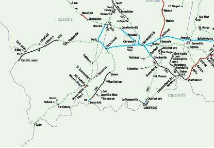
In 1962, the New York Central encompassed 9,103 route-miles (including jointly owned properties) plus 872 miles of trackage rights, for a 9,975-mile system. This did not include lines that had a corporate affiliation but were operated independently — and therefore aren’t shown here as part of the system — such as Pittsburgh & Lake Erie, Indiana Harbor Belt, Indianapolis Union, and Toronto, Hamilton & Buffalo.
As of 2007, about 55 percent of NYC’s system remained in service, consisting of about 5,420 route-miles. CSX accounted for 40 percent of the active mileage, operating about 2,150 route-miles, while Norfolk Southern’s 1,400 route-miles comprised another 26 percent. Four other Class Is owned 183 miles, or 3 percent. The 34 short lines operating 1,200 miles accounted for another 22 percent of active line segments; Amtrak and three commuter agencies ran 5 percent; and eight tourist railroads had 3 percent.
By contrast, only about 44 percent of the Pennsylvania Railroad’s 9,600-mile system of 1965 was still in service (see the February 2006 Trains Map of the Month).
Railroads included in this map:
Adrian & Blissfield; Ashtabula, Carson & Jefferson; Adirondack Scenic; Amtrak; Baltimore & Ohio; Buffalo & Pittsburgh; Chesapeake & Ohio; Chicago, Burlington & Quincy; Camp Chase; Chicago, Fort Wayne & Eastern; Chicago, Rock Island & Pacific; Central Railroad of Indiana; Carthage, Knightstown & Shirley; C&NC Railroad; Catskill Mountain; Canadian National; Canadian Pacific; Conrail; CSX Transportation; Columbus & Ohio River; Delaware & Hudson; Depew, Lancaster & Western; Delaware & Ulster; Erie; Elkhart & Western; Finger Lakes; Flats Industrial; Falls Road; Great Lakes Central; Genesee & Wyoming; Huron & Eastern; Housatonic; Illinois Central; Indiana Harbor Belt; Indiana Northeastern; Indiana & Ohio; Illinois Railway; Indiana Southern; Kankakee, Beaverville & Southern; Kansas City Southern; Lake State; Lycoming Valley; Massachusetts Bay Transportation Authority; Massachusetts Central; Mohawk, Adirondack & Northern; Metro-North Railroad; Michigan Southern; NJ Transit; Nickel Plate; Norfolk Southern; Oil Creek & Titusville; Ohi-Rail; Ontario Midland; Ohio Southern; Pan Am Railways; Pennsylvania; Rock Island; R.J. Corman; Cleveland Regional Transit Authority; Rutland; Shelbyville Industrial; Southern Michigan Railroad Society; Somerset; Trolley Museum of New York; Union Pacific; Vermillion Valley; Wellsboro & Corning; Whitewater Valley


My uncle Howard T. Harper was a bridge inspector/civil engineer in Indianapolis post WW2 and within Ohio after graduation from OSU in ’44 and before being drafted into the US Army.