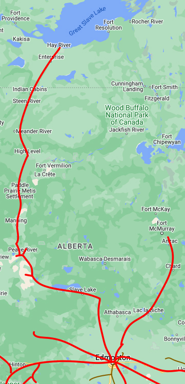
HAY RIVER, Northwest Territories — Canadian National Railway has begun the process of ending service to Hay River, which currently holds the distinction of being the northernmost point connected to the North American rail network.
Cabin Radio reports the railroad filed in May to discontinue service on its Meander River Subdivision between mileposts 354 and 376, most of the route between Hay River and Enterprise, NWT, some 40 kilometers (25 miles) to the southwest. Much of the track between the two communities was damaged in a wildfire last year.
A CN representative said in an email to Cabin Radio that the decision came after “thoughtful engagement with local stakeholders and customers.” The email also said that after last year’s fires, the railroad had reallocated resources to restore service to Enterprise “to meet customer commitments” and that its engagement with customers and a cost analysis “revealed that the costs of repair for the lines were not proportional to the volume commitments of customers in the region.”
But the decision raises concerns about supply-chain issues for the remote communities of the Northwest Territories, the territories’ infrastructure minister, Caroline Wawzonek, told the CBC.
“It has a tremendous effect on really some of the most vulnerable Indigenous communities in the North,” Loss of the rail line will require trucking cargo from Enterprise to fill a link in the current rail-and-barge chain, and will lead to higher supply costs. A six-hour trip by truck from Hay River will become an 80-hour trip from Enterprise, she said.
Abandoning the line will require a three-year process. After a year, CN can attempt to sell the segment, but Wawzonek said a territorial government purchase “isn’t an appropriate use of tax dollars.” Similarly, the government said it is not willing to provide the $15 million needed for repairs. (Cabin Radio notes that the territorial government has an annual revenue of about C$2.5 billion compared to the railroad’s C$17 billion.)
A former Hay River mayor who owns a rail yard in Enterprise that is a transloading hub, and will gain even greater significance, says the move may simply reflect changes that have already begun and will accelerate if the proposed Mackenzie Valley Highway, an all-weather road in the region, is built.
The former mayor, Brad Mapes, told Cabin Radio, “The logistics of the North has changed, and it’s only going to change. … As the Mackenzie Valley Highway goes, the less and less barging is going to happen.” Historically, fuel and other cargo were delivered by train to Hay River, then moved by truck to Yellowknife or by barge on the Great Slave Lake to other communities.
The highway, however, does not have yet have funding or a timeline for construction. And this summer, the normal barge service has been disrupted by low water levels on the Mackenzie River, meaning much of the usual cargo traffic is being brought in by air, a far more costly operation.
Hay River is, by straight-line distance, some 510 miles north of Edmonton, Alberta. It is some 193 miles from the southern end of the Meander River Sub, in High Level, Alta.
There are many unknown reasons why this line needs to remain open. “Abandon it today, need it next year”. Wild fires happen and should not be a reason to abandon an important link, now or in the future, to the north.
I think Paul Harvey might think there is “the rest of the story” with this. Barge traffic on the Mackenzie has been negatively affected by low water levels for three years now. $15 million is hardly a huge expenditure to preserve a piece of infrastructure which accesses Great Slave Lake. Evidently the Northwest Territories thinks there never will be any kind of economic venture in the future that could be established along the lake to take advantage of shipping directly from the railhead in Hay River to a point along the lake. (The highway trip from Enterprise or Hay River to Yellowknife is more than twice as far as a barge trip from Hay River to Yellowknife.) Sure, barging on the lake is seasonal, but even the road to Yellowknife also was until 2006 when a bridge replaced the ferry across the Mackenzie near Fort Providence. Elsewhere in the territory, roads still require ferries over major rivers (or ice bridges in the winter) or ice roads in the winter. Seasonality is just a way of life.
The government also seems to think low water situation is permanent. It might very well be, given it is likely driven by climate change. On the other hand, if water levels are restored, existing infrastructure at Hay River would be the cheapest to reinstate. Besides, there doesn’t seem to be much a “plan B.”
Despite the “concerns” from the infrastructure minister, I can’t help but wonder if the Territory’s reluctance to fund repairs to the railroad is simply a ploy to make a bad situation more dire to get Ottawa’s attention to fund the Mackenzie River highway. (The article says the Territory can’t afford to fix the railroad, but the federal government is the entity that funds such projects in the Canadian North.) Even so, building such a highway would take years – maybe even decades. And billions of dollars…..Even more than the proposed Amtrak train from Minneapolis to Denver across South Dakota (and that’s A LOT). And that former mayor of Hay River who owns the transload facility in Enterprise seems to be a bit too eager to let the railroad to Hay River go away. Of course it would benefit him. I bet the people in Hay River are glad he’s not THEIR mayor anymore. With friends like that…..
More information:
https://e360.yale.edu/features/canada-mackenzie-river-highway
By the way, Cabin Radio mentioned in the TRAINS article isn’t conventional. It’s an Internet “station” with quite an interesting mix of music, and not what you might expect from Yellowknife.
https://cabinradio.ca/live/
So which is it? Climate change causes drought, or climate change causes more rain? We hear both on a regular basis. Truth is this: we have had droughts and floods for all recorded history, when population levels, energy use, polution, etc. were tiny fraction of today’s environmental impacts.
Water levels in the Great Lakes rise and fall for reasons best known to the gods of Great Lakes water levels. Some years you can boat on Lake St. Clair along the Detroit shore line and look down at the houses past the dikes. Some years the water levels drop. No one knows why.
Has the opening of the Deh Cho Bridge at Fort Providence over the Mackenzie River really changed the traffic patterns that much? The bridge has been open for over 10 years.
No. That has nothing to do with it. The issue is the lower river water level no longer supports seasonal navigation. If the addition of roadways significantly affected transport, then most of the lading would already be transloaded at Enterprise and transported by truck to someplace like Fort Simpson, and then on the Mackenzie from there. But until 2022 (when the low water situation began in earnest), Hay River remained the primary transloading point for Mackenzie River settlements.
@ Mark; I just looked up the Mackenzie River Valley highway plan to extend the all-season route from Wrigley to Tulita including the Great Bear River Bridge.
That adds some clarity to the discussion for me.
As for the length of time, the Mackenzie Highway is not paved for year round use all the way up the river. These roads can be closed for various reasons like nearby fires, washouts, fog, mud etc.
Many years ago I drove through Hay River. I saw the tracks, but no trains. My impression at that time was that fuel trains bound for barges was the primary traffic, and seasonal only, since barges operate seasonally. Pretty area–wide open views, not many people.
Paragraph five reads,
She said, A six-hour trip by truck from Hay River will become an 80-hour trip from Enterprise.
A couple of sentences must be missing, not sure how losing train service can equate to a 74hr. difference in travel time.
Minister Wawzonek was referring to indigenous communities to the north of Hay River.
I read that as the difference in distance between Hay River and Enterprise, 6 hours from the former to the lake barge, and 80 from the latter. Could be wrong though.
It seems that this Hay River line could be a link to Alaska with the Alberta-Alaska Railway Development Corp., (A2A), project. That should make this CN branch cost effective.
If memory serves, the A2A would prefer to connect to the NA network at Fort Nelson, southwest of Hay River.
Hello John Rice, here’s a map showing some various A2A proposals which includes the possibility of tying into both branches. https://mediad.publicbroadcasting.net/p/kuac/files/styles/x_large/public/202008/A2Amap1.png