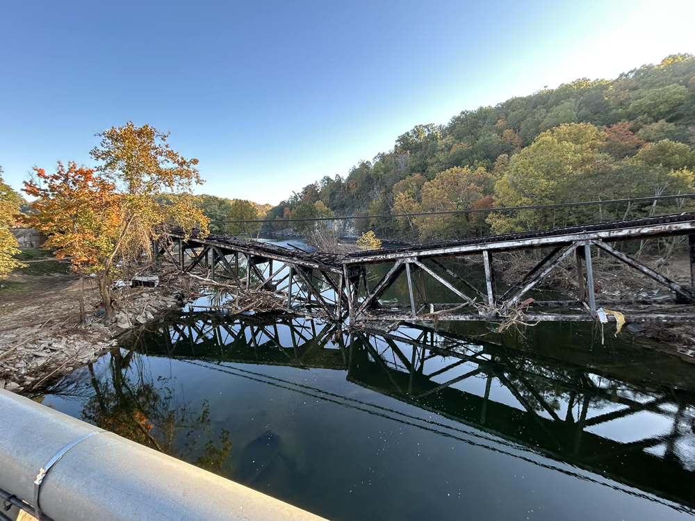
NEWPORT, Tenn. — A trestle on Norfolk Southern’s storm-closed AS Line in Tennessee collapsed Wednesday, leading to a series of road closures, Newport police reported.
Three roads are closed until further notice as a result of the collapse of the bridge over the Pigeon River, the police said in a Facebook post.
The NS line is already out of service between Newport and Asheville, N.C., until at least the end of January because of September flood damage in the wake of Hurricane Helene, the railroad said earlier this month [see “Norfolk Southern line into Asheville …,” Trains News Wire, Oct. 10, 2024]. Newport is 64 rail miles northwest (timetable west) of Asheville.
— Updated Oct. 29 at 4:40 p.m. to correct timetable direction in final sentence.


Once again:
The railroad line here is Norfolk Southern’s “S” line. [NOT “AS”].
And: From the article – “Newport is 64 rail miles northwest (timetable east) of Asheville.”
It IS actually timetable WEST of Asheville.
You need to take the first point up with Norfolk Southern. Its media release on the line reads, “In the hardest hit areas, along Norfolk Southern’s AS Line, which runs from Salisbury, N.C to Morristown, Tenn., …”
As to the second, you are correct and I will correct it. I misread the company timetable, seeing the word “West” above Asheville but not the arrow below it.
It appears that there was a pier (bent) that supported both spans now missing. Question is, was the pier missing prior to this collapse (unlikely) or the pier tumbled over from water pressure allowing the spans to collapse. Definitely appears that river scour undermined the pier cap or spreader footer on the bottom of the river? To fix this a question is how or can NS replace a pier cap in the river without removing the spans temporary? Plus, how much damage to the spans?
Appparently NC DOT is being cautious closing other bridges over the river until those bridges are verified to not have scour problems. Scour can happen either on river bottom or on its banks.
In earlier photos of the bridge taken immediately after the flood the pier was still standing, but leaning substantially. The pier had initially lost some elevation as well since there was a noticeable dip in the bridge over the pier. At some point in the last week the pier tipped over into the river. The pier is visible resting on its side in the water under the span that occupies the right side of the photo. As you mention, the pier’s foundation was likely undermined by scour causing it to lose elevation and rotate. Chances are the anchorage to the truss spans was the only thing keeping the pier upright and sometime in the last few days that anchorage let loose and the pier tipped over.
It is probably more stable now than it was last week. Trying to shore up those spans with the threat of the pier toppling over was not ideal. They’ll have to raise the spans a little higher, but the rest of the scope isn’t much worse than it was before.
All NS needs is a god memory and plan of the Tye River collapse and this one will be fixed shortly.
The Tye river bridge was on a main line that was probably handling 20 or more trains a day. This line has one train a day. Don’t expect the same response.