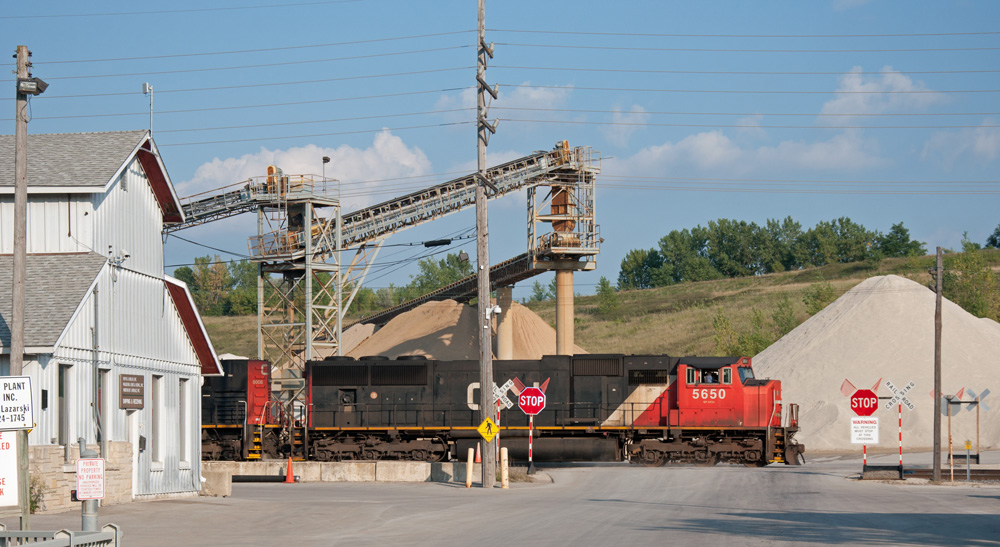
A southbound Canadian National freight rolls through a limestone quarry in Waukesha, Wis., in August 2011. Stone, sand, and gravel make up the largest source of originating traffic on Wisconsin railroads. Photo by Matt Van Hattem […]
Read More…
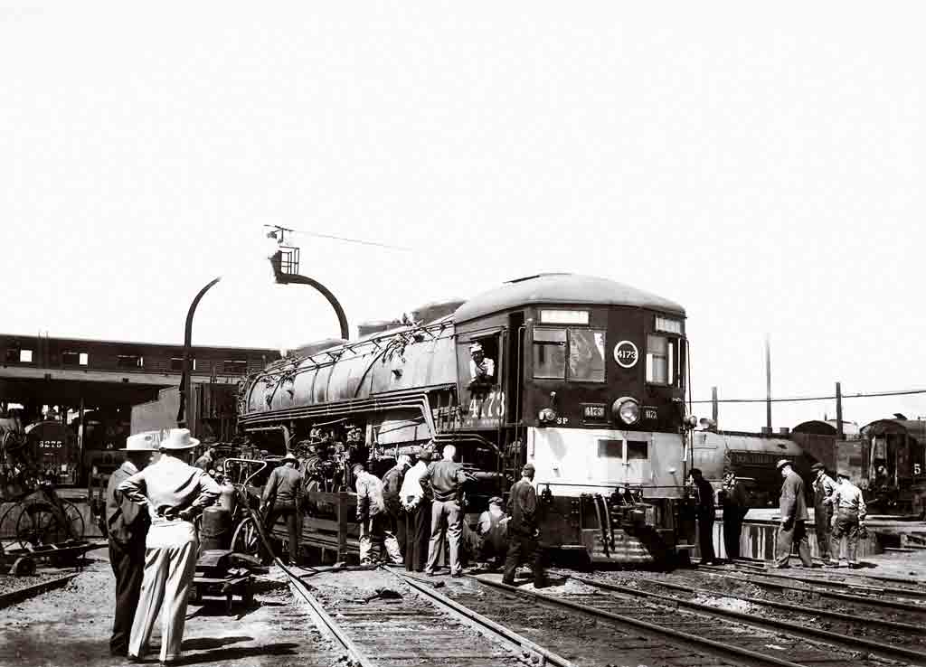
When SP cab-forward 4173 derailed on the turntable at Tucson, “suits” and laborers reported to the scene. R. S. Plummer, Gordon Bassett coll. I have been collecting old black-and-white railroad negatives for nearly 30 years. When I receive a new batch, it’s like Christmas, opening the package and sorting through the stuff. You never know […]
Read More…
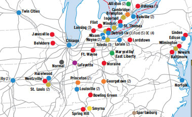
In the early 2000s, North America’s 88 automobile assembly plants produced about 15 million new cars and trucks a year. And railroads moved 70 percent of the vehicles built in the United States alone. Most Canadian and U.S. plants are concentrated in a wide corridor stretching from Toronto to Mobile, Ala. Plants in Mexico are […]
Read More…
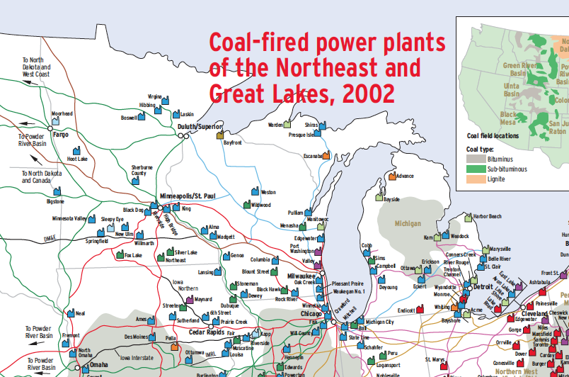
Coal is the most important rail commodity in the United States. In the early 2000s, when this map was produced, coal accounted for one of four cars loaded and slightly more than 20 percent of rail revenue. Eighty percent of the coal goes to the generation of electricity at steam power plants, so a map […]
Read More…
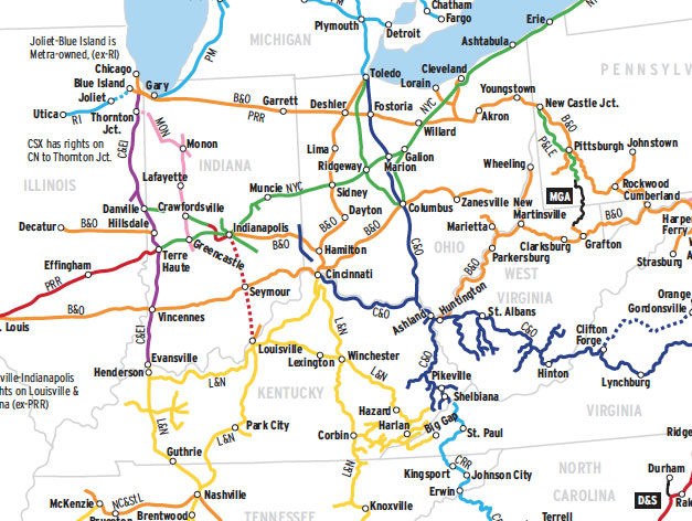
Geographic growth by acquisition or merger, and the elimination of redundant routes by sale or abandonment, are two factors that have been with American railroading from the outset…and are not about to go away. Consider this map of CSX Transportation’s principal ancestors. Shown here are 22 former Class I railroads — in post-World War II […]
Read More…
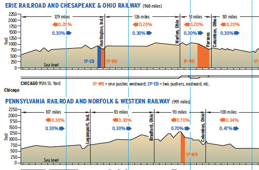
Compared here are the main lines of railroads that, for most of the 20th century, fed the nation with its most important natural resource: bituminous coal mined in Appalachia — the critical ingredient in power plants, steel mills, home furnaces, and factories. In 1927, the year of our comparison, the Chesapeake & Ohio and Norfolk […]
Read More…
Commercial shipping on the Great Lakes follows a 2,300-mile corridor from the St. Lawrence Seaway to the western edge of Lake Superior. Over 200 million tons of cargo a year cross the five lakes and connecting waterways, hauled in some 150 U.S. and Canadian lakers, 50,000 barges, and about 1,000 visits by ocean-going vessels, or […]
Read More…
This Map of the Month was featured in the February 2009 issue of Trains magazine. The railroad Abraham Lincoln so ardently championed in the 1800s had changed dramatically in the ensuing century. On a mainly double-track speedway (enhanced with Automatic Train Stop in Illinois), diesel locomotives rushed goods from Gulf Coast ports and farms to […]
Read More…
This Map of the Month appeared in the February 2004 issue of Trains magazine. Historians have argued that one key to the success of Norfolk & Western’s 1982 consolidation with Southern Railway was that the railroads shared a similar culture — determined, forward-looking, and committed to success. This served to douse the fires of early rivalries […]
Read More…
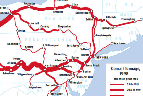
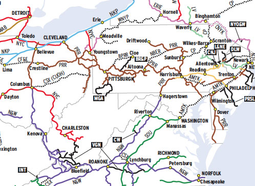
Twenty-four years separate these two density maps — a long time in North American railroading. The 1974 Penn Central map uses the last data available for the failed railroad; the 1998 Conrail map likewise is based on the last data before its system was split between CSX Transportation and Norfolk Southern. While similarities appear, the […]
Read More…
An English import, the American railway diverged sharply from English ideals. Environment proved stronger than genetics — settled and industrializing England constrained railway builders to design the most efficient routes possible, whereas their counterparts in unsettled and impecunious America disregarded gradient and circuity on pain of not completing lines at all. As the American era […]
Read More…
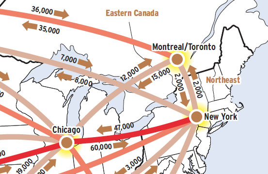
This Map of the Month was featured in the August 2004 issue of Trains magazine. This map shows a commodity flow, or what everyone treats as a commodity flow: the trailers and containers that move in intermodal lanes in the U.S. and Canada. These boxes might actually contain anything from hay to helicopter parts, but almost […]
Read More…
