BALTIMORE — Three rail options are among the seven alternatives for a north-south transit corridor in the Baltimore region, for which the Maryland Department of Transportation ended public comment on Nov. 7. Comment on seven alternatives for east-west corridors concluded Aug. 1.
Both sets of corridors are part of the Central Maryland Regional Transportation Plan, a 25-year-plan initiated in October 2020 for improving public transit in Baltimore and four surrounding counties. They are considered the highest priority needs for transit in the region.
All seven alternatives for the north-south corridor are designed to link Towson, the Baltimore County seat, with downtown Baltimore City. Four of the alternatives would be improvements to bus service over existing streets or to-be-built dedicated infrastructure.
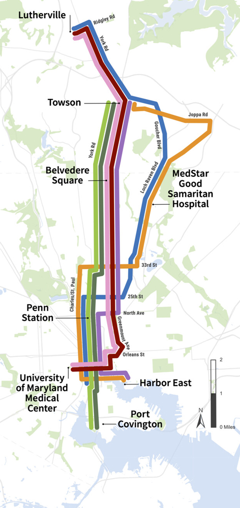
The seven options, as shown on the color-coded map at right from MDOT, are:
1. (pink): Light Rail Transit from Lutherville to University of Maryland Medical Center (UMMC) via York/Greenmount.
2. (maroon): Bus Rapid Transit (BRT) from Lutherville to University of Maryland Medical Center (UMMC) via York/Greenmount.
3.(purple): BRT from Towson to Harbor East, via York/ Greenmount.
4. (light green): Heavy Rail Transit (Subway) from Towson to Port Covington, via York/ Greenmount.
5. (dark green): BRT from Towson to Port Covington, via York/ Greenmount.
6. (blue): Light Rail Transit from Lutherville to Otterbein, via Goucher, Loch Raven.
7. (orange): BRT from Towson to Harbor East, via Joppa, Loch Raven.
The seven alternatives for the east-west corridor are designed to link the existing north-south rail transit options: Baltimore Light Rail, which runs from Hunt Valley to the north to Baltimore-Washington International Airport (BWI) to the south; and the Baltimore Metro Subway, which runs from an isolated station along Interstate 795 northwest of Owings Mills, Md., to downtown Baltimore. Three of the alternatives would extend to Ellicott City to the west, and two others would extend to Essex to the west. Like the north-south alternatives, three would be rail systems and four would be improvements to bus service over existing streets and highways or to-be-built dedicated infrastructure.
Here are those options, with their color-coded descriptions below:
 1. (green): BRT from Bayview to Ellicott City via Johns Hopkins Hospital and the Centers for Medicare and Medicaid Services (CMS) and the Social Security Administration (SSA).
2. (purple): BRT from Bayview to Ellicott City via Johns Hopkins Hospital and US 40.
3. (orange): Heavy rail (Metro SubwayLink) Transit from Bayview to Edmondson Village, BRT from Edmondson Village to Ellicott City.
4. (light blue): Light rail from Essex to CMS/SSA via Bayview and Johns Hopkins Hospital.
5. (khaki): BRT from Essex to CMS/SSA via Bayview and Johns Hopkins Hospital.
6. (yellow): Light rail from Bayview to CMS/SSA via the waterfront.
7. (dark blue): BRT from Bayview to CMS/SSA via the waterfront.
Of the seven east-west options, No. 6 resembles the Red Line light rail project, for which planning began in 2001, only to be killed by Gov. Larry Hogan following his election in 2014.
With the public comment complete, MDOT and the Maryland Transit Administration will use the information they’ve gathered in engineering and environmental analyses to select a preferred option for both the north-south and east-west routes. After that, it will be up to newly elected Gov. Wes Moore, a Democrat, and the state’s General Assembly — both houses of which are also controlled by Democrats — to determine what comes next.




Baltimore Heritage – five-minute histories covers.
Wow. Starting to look a lot like the old Baltimore streetcar lines map from seventy years ago.
Have they thought of reviving the Red line project that Hogan canned in 2015?