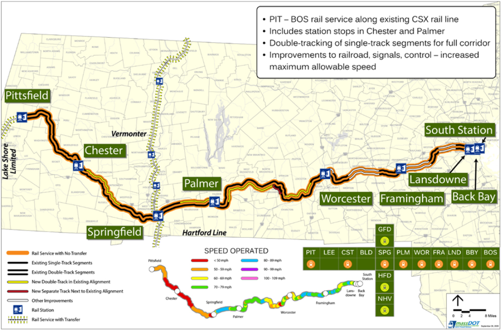
BOSTON — The Massachusetts legislature has passed a transportation bill including $275 million in funding for the East-West Rail project, which would extend existing rail service west from Worcester to Springfield and Pittsfield, Mass.
The Boston Globe reports the $11.3 billion transportation and infrastructure bill was part of a flurry of legislation passed late Sunday and early Monday, as the legislature reached and passed a midnight deadline for the end of its session. The session finally ended about 5 a.m., after lawmakers suspended their rules regarding the deadline.
The bill now goes to Massachusetts Gov. Charlie Baker, who has 10 days to sign or veto it.
Earlier this year, Baker and U.S. Rep. Richard Neal announced a plan for a new state rail authority to oversee the project and seek federal funding [see “State, federal officials announce agreement …,” Trains News Wire, April 27, 2022]. A 2021 report estimated costs for various versions of the project ranged from $2.4 billion to $4.6 billion.




Charles L That was a trick question on longest town.Gosnold is made up of a group of islands.Does anyone know what happens when a bad snowstorm hits ,do they have a plow truck.Also,do they have a one room school house.I believe Chronicle did a show on the islands and mentioned a high school student went off island.A great place for Thorough,spelling?,to live.
I LOVE TRAINS BUT,it would be more cost effective to add a 4th lane on mass pike from 95 to Sturbridge which anyone that commutes or drives on a Friday night holiday will attest to.The mass pike was built around 1960 and has NOT changed since than.The off ramps from 95 or 290 to pike go in a figure 8 and can go only 25 mph. State line was changed ,at one time Bristol RI was part of MA,longest town Plymouth or Hancock,largest I think carver,
Steven —
Answers: Yes Bristol, Warren and Barrington were ceded to Rhode Island. Making three-town Bristol County Rhode Island the second – smallest county (by area) in USA, one above a county in Hawaii. Site of Roger Williams College. Only place in America where you can cross a state line to be in a county of the same name.
The longest city or town, furthest point to furthest point, is Gosnold in Dukes County. Population about 90. So you were wrong about Carver, Hancock or Plymouth being the longest (but good guesses – Wareham would be another good guess). Plymouth, however, is the answer to different trivia question, the largest town by area, more area than any city such as Boston or Newton or Quincy.
Carver of course was the site of the Edaville Railroad tourist line of blessed memory.
Your note about Mass roads not changing since 1960 is accurate. I’ve shown roads to my wife (born in NE Wisconsin) saying I drove on them in the 1960’s and they’ve not changed.
The connecting ramps from Mass Pike to I-290 or I-495 were of course built for toll booths which is why they’re so 1960’s screwy.
MASS DOT is the process of redesigning the Pike / 495 interchange that would remove the existing connecting ramps and streamline the interchange. One problem, the whole interchange is surrounded by swamps and a river.
I still can’t help but wonder if it would be better to team up with New York and extend the service all the way to Albany instead of dead-ending at Pittsfield. Extending to Albany would increase connectivity with Empire Service (and other trains) and allow them to use existing maintenance and layover facilities. Stopping at Pittsfield removes that connection and requires building more facilities, which is expensive.
Well obviously yes. No need to “wonder”, Daniel, the answer is yes. Pittsfieldis in the same state as Boston – which is the only reason why anyone would think Pittsfield – Boston is a viable corridor.
I was going to ask the same thing. Need to confer with NY state to make this work, though it seems the benefit is more to MA than NY.
Amtrak rebuilt (and I believe owns) the Post Road connector for a grand total of one train pair daily.
That is correct. The original routing of the Boston section was to go onto the bridge over the Hudson and then back down to the mainline and head to the station. When I lived right next to the Post Road in the late 80’s the Boston section would fly by at 79 MPH.
Mass. has no unincorporated areas, as with CT.
Also Rhode Island.
Dan and Lawrence …. Since you know your way around the Bay State, here’s 3 trivia questions:
(1) Why did Bristol County seat change from Bristol to Taunton?
(2) What is the largest city or town by square-mile area?
(3) What city or town sprawls over the largest distance, counting a straight line measurement from furthest point to furthest point.
Charles, Unlike many other states, Massachusetts has an extremely limited County Government system – Except for the court system and records, it goes from the State level pretty much right down to City/Town level for much of everything else run/provided by the government.
See my comment on another article this morning. The Boston and Albany once was double-iron. The Commonwealth has to pay to restore what once was.
BTW, off-topic, love that map! 351 cities and towns (some barely populated), no counties.