CHICAGO — Metra will open its newest station, and expand service on its Union Pacific North Line — which includes that station, Peterson/Ridge — on Monday, May 20, the commuter rail operator has announced.
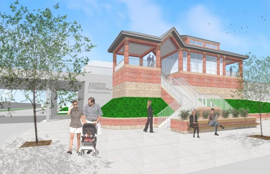
Peterson/Ridge is in Chicago’s Edgewater neighborhood. Groundbreaking was held in November 2021, on what at the time was projected to be a $22 million, 18-month project [see “After 12 years, Metra holds station groundbreaking,” Trains News Wire, Nov. 2, 2021]. It becomes the 28th station on the UP North Line, including the seasonal stop at Ravinia Park. The station, at 1780 West Peterson Avenue, takes its name from the streets that define the triangular plot on which the station sits. The railroad tracks providing the third side.
Schedules introduced on May 20 will include two additional inbound and two outbound trains, as well as schedule adjustments to allow for the additional stops at Peterson/Ridge. One of the new inbound trains will originate in Waukegan at 5:35 a.m., arriving in Chicago at 6:55 a.m.; the other will originate in Winnetka at 7:53 a.m. and arrive in Chicago at 8:35 a.m. The added outbound trains will depart Chicago at 6:40 a.m., serving intermediate stations to Highland Park, and at 4:50 p.m., serving intermediate stations to Winnetka. The full new schedule is available here.
“We continue to monitor customer feedback and this new schedule shows that we are listening,” Metra CEO/Executive Director Jim Derwinski said in a press release. “In addition to the new trains, riders in Kenosha and Waukegan as well as reverse commuters will now have more options. The grand opening of our new station at Peterson/Ridge also provides another much-needed access point to our service.”
MICHAEL — Thanks for info on CNW history.
Two kinds of METRA stations, the grade-separated in Chicago (and inner ring cities like Oak Park, Evanston, etc.), or the level grade stations out in the ‘burbs. Most of the grade-separated stations are dated and drab, like the New York City subways, as well as inaccessible for wheelchairs. Bringing the grade-separated stations up to current standards is to say the least challenging. Where I’ve seen laudable progress is on the Metra Electric. In this process, we’re not talking years, we measure progress in decades.
Someone at CDOT / Metra / 30th, 48th, 47th Wards / Streetsblog / Etc. — hopefully some very smart and talented people — better be thinking very hard and very quickly about DRASTICALLY IMPROVING bike-ped access to / from the new Peterson Metra Station, from all directions — from the east, from the north, from the west, and from the south. Right now, the dangerous, disastrous mess that is the Ridge-Peterson-Clark-Ashland triangular “intersection(s)” is ridiculously car-centric and very dangerous for all roadway users. I have witnessed CTA bus riders get off EB bus at Ridge-Peterson and step into the street where 40 mph vehicles are making the “soft” right turn from EB Peterson to SEB Ridge (near the “Heart o’ Chicago” Motel) — inches away from getting instantly obliterated on the south leg of Peterson-Ridge intersection: https://www.google.com/maps/@41.9907431,-87.6724555,3a,90y,100.56h,88.11t/data=!3m6!1e1!3m4!1sDMOkHHhbEhutZQ6_YZPgzw!2e0!7i16384!8i8192?coh=205409&entry=ttu. VERY SCARY, and just one of many dangers for peds and bikes in this area, where the new Peterson Metra Station is set to open, I believe, later this month!
AGAIN: For vehicles going EB on Peterson, east of the Metra tracks there are two right turn lanes at th signal where Peterson becomes Ridge. Around 30-40K cars day traverse this corridor. The double-lane right turn from Peterson onto Ridge is a “soft” (oblique) right-turn and vehicles in these lanes, when they have green the right-turn arrow, take this soft right turn at 25-45 mph. However, at this location there is a bus stop. Officially, the south leg of Peterson/Ridge (right next to the bus stop) is not a ped crossing (no ramps, no marked crosswalk), but bus riders don’t know this. They assume that, in Chicago, all legs are crossing locations. They get off the bus, the pulls off and makes the right turn onto SEB on Ridge. Then, the peds (looking at their phones) step off the curb on the south leg into high speed traffic (making the soft right on green arrow). See Google Steetview: https://www.google.com/maps/@41.9907431,-87.6724555,3a,75y,104.9h,80.62t/data=!3m6!1e1!3m4!1sDMOkHHhbEhutZQ6_YZPgzw!2e0!7i16384!8i8192?entry=ttu
Agreed – not a nice area at all for anyone walking or biking. It is a densely populated area though so the station should get some good use.
Hey Trains Staff: How about including a map in the post to show where the new station is located. Most of your readers are not Chicago locals:-(
Google is your friend. It’s also on Apple Maps already.
https://maps.app.goo.gl/ucHgKh9cifhwNF4m8
The C&NW closed many of its closer-in stations in the city of Chicago on Dec. 1, 1958, as part of a modernization of its suburban service, leaving just two north of Clybourn before reaching Evanston, and it closed two there. Now a third station is being added back in Chicago.
CNW reducing its “in Chicago” footprint as part of its modernization in 1958 was a political/financial arrangement.
It saved the CNW money by reducing the number interline switches that had to be maintained, and it was political because Daley the First was working to kill the weak interurbans and wanted the city to run the local transit through the CTA.
So a tradeoff. More suburban service for the CNW, less competition for the CTA.