


Montana’s U.S. Route 2
The former Great Northern “Hi-Line” across Montana is BNSF’s primary route to the Pacific Northwest. The BNSF route across Montana is paralleled by U.S Route 2 instead of an interstate highway and is a boon to the railfan.
For 557 miles, U.S. 2 is alongside BNSF from Whitefish in the western Montana mountains to Williston, just over Montana’s eastern border in North Dakota. BNSF’s CTC-equipped main line hosts about 30 daily trains (more when grain is moving), providing ample train-watching targets while driving.
Start your trip with the morning arrival of Amtrak’s eastbound Empire Builder at the ex-Great Northern depot in Whitefish. The Stumptown Historical Society owns Whitefish’s 1928 alpine-style depot along with a rare Electro-Motive NW3 in GN colors trackside. BNSF’s Whitefish yard is active (including a turntable and partial roundhouse) and BNSF crews and Amtrak engineers change here. BNSF’s “snow coaches” may be in the yard — rebuilt former Santa Fe Hi-Levels used to move crews when roads are impassable.
After leaving Whitefish and picking up U.S. 2, cross GN’s original main line that ran via Kalispell and was bypassed in 1904. Watco leased the branch until 2020, and now BNSF services the line with a daily local. The main line is mostly out of sight for the next half hour, unless you detour into Columbia Falls to see a lonely Shay locomotive displayed along Railroad Street.
West Glacier boasts both mountain views and adjacent tracks. The left turn under the tracks marks the entry to Glacier Park’s Going-to-the-Sun Road, but go straight ahead to Amtrak’s 1910 West Glacier station (BNSF calls it “Belton”). The railroad has been following the Flathead River uphill since Columbia Falls and eastbounds face a 0.5% grade.
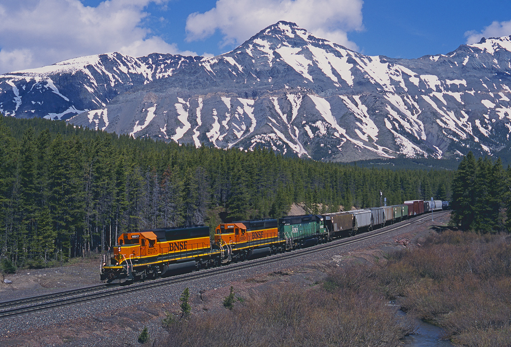
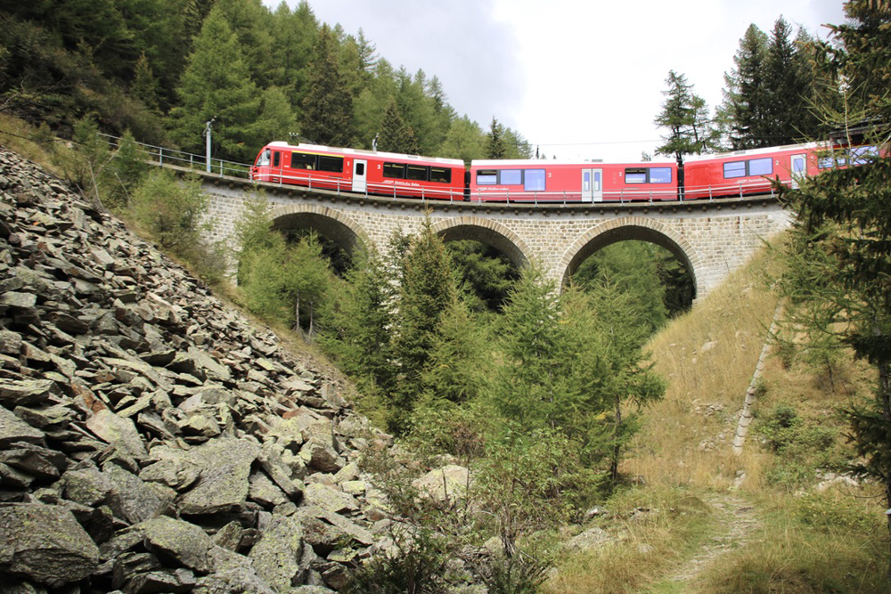
BNSF and U.S. 2 follow the southern border of Glacier National Park for the next 50 miles, climbing Marias Pass together at on a railroad grade that reaches 1.8% eastbound and 1.2% westbound and crosses the Continental Divide almost a mile above sea level. Twenty-five miles east, pause at Essex’s railfan-themed Izaak Walton Inn where guests could stay in cabooses or a GN-painted F45 locomotive in addition to the historic main building. Alas, much of the inn’s rail decor was sold at auction and the inn is closed for renovation as of this writing. If the inn is open, you’ll find it a fantastic place to stay and watch trains in comfort; otherwise stop in for a meal or a drink.
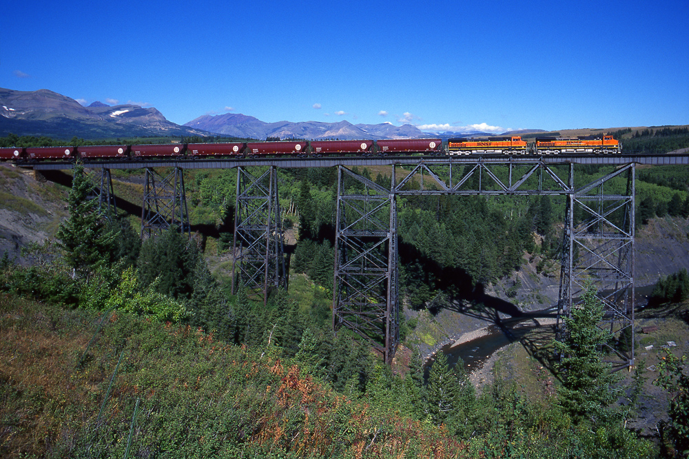
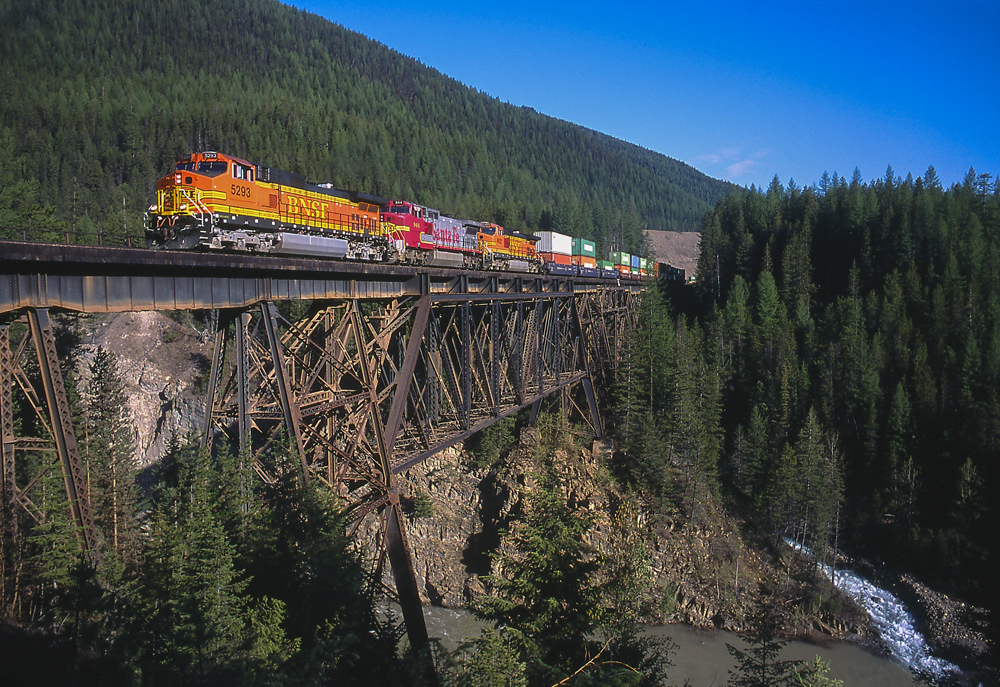
The scenic Java Creek and Sheep Creek tall steel bridges can be seen from U.S. 2, and the grade stiffens as BNSF and road leave the Flathead River valley. The railroad passes through numerous snowsheds as it winds and climbs the next 15 miles to the top of Marias Pass. At aptly-named Summit there’s an obelisk to complement incredible views of the Rockies. BNSF has a balloon track at Summit to turn snow-fighting equipment, and look for the Summit Mountain Lodge, a heavily remodeled but still recognizable former GN station moved here in the 1980s.
The scenery changes on the east slope of Marias Pass as mountains fade into foothills. East Glacier’s 1912 log depot is a seasonal Amtrak stop, but the main attraction is the prominent GN-built Glacier Park lodge. Just east, Route 2’s Two Medicine River bridge becomes a photographer’s tripod, providing a postcard-perfect view of BNSF’s massive steel bridge over the same river complete with extra-photogenic barn. Browning features BNSF views from Route 2 overpasses on either side of town, but otherwise road and rail take different routes through town. East of Browning the railroad and U.S. 2 are side-by-side out on the plains for 10 miles starting at Blackfoot.
Cut Bank, only 30 miles south of the Canadian border, is the next sizable town. Before entering Cut Bank, the railroad crosses the Cut Bank Creek on another imposing steel trestle. A former crew-change point with a small yard, Cut Bank’s GN depot is still used by Amtrak. Rail and road run next to each other for 13 miles between Ethridge and Shelby.
While Shelby is about the same size as Cut Bank, there’s a lot more going on. The intersection with I-15 means more places to eat and sleep, and Shelby is a junction with the BNSF’s Sweet Grass Subdivision to the Canadian border, and with the Great Falls sub headed south. BNSF dispatches a daily turn from the Shelby yard to interchange with CP at Sweet Grass and the route also hosts varied but occasional unit trains. The Great Falls Subdivision is usually quiet (a scheduled train pair plus unit grain trains) but boomed as a detour route when a Montana Rail Link bridge collapsed in 2023. Route 2 nearly runs across the Great Falls/Hi-Line junction switch on Shelby’s east side.
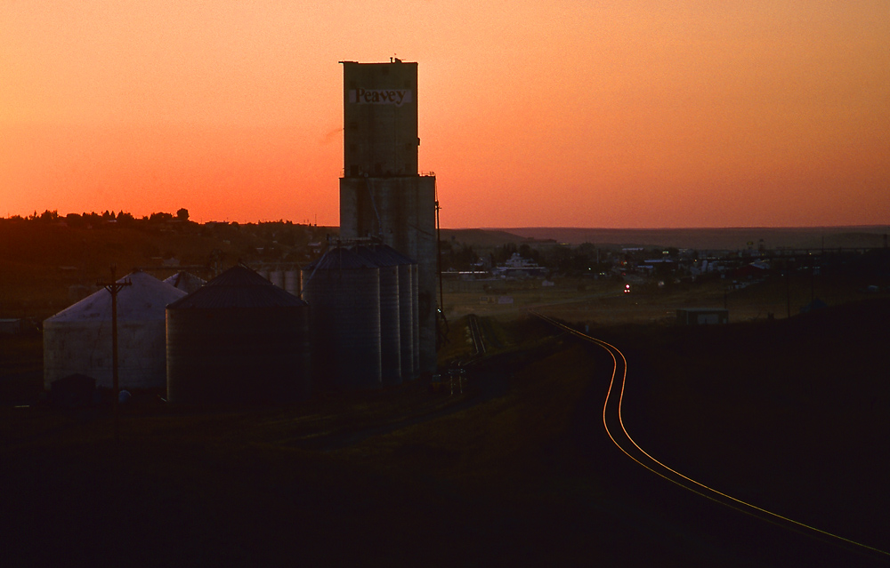
Make sure you are fed, watered, and fueled before you leave Shelby because it’s a hundred miles of not much to Havre. Fortunately, the “not much” does include a lot of road and rail side-by-side running. Many towns still have old-style grain elevators that add interest to photos in these wide-open spaces. Chester has two unit-train loading loops and Rudyard’s miniature-but-cute Sugar Shack Diner is worth a stop.
Havre hosts both crew changes and a locomotive shop and is a hot spot. Ironically, the shop’s isolation helped it dodge several closure attempts, because its closing would require towing dead locomotives long distances. Havre’s Amtrak station is only a block off U.S.2, although its 1904 construction is hidden by the mid-century vibe from a 1949 remodeling. Check out the James J. Hill statue out front and the well-kept GN 4-8-4 next to the platform. Havre’s 7th St. overpass gives good views of the shop and yard, but be careful — no sidewalks!
Havre is a good halfway point for a two-day trip. The appropriately-named Best Western Great Northern Inn is conveniently located on U.S. 2, featuring views of the turntable and engine servicing areas from back-side rooms.
Starting just west of Havre, the Hi-Line and U.S. 2 are in the Milk River valley for the next 175 miles. Rail and road are almost never out of sight of each other for almost 50 miles until Harlem. U.S. 2 picks up the Hi-Line 28 miles later at Dodson, but hardcore fans can instead brave Montana 396 right next to the tracks.
Route 2 reconnects with the tracks at Malta, an Amtrak stop with another GN chalet-style wooden depot. Ridership is surprisingly strong at the small towns along the Hi-Line: Malta’s annual ridership more than doubles the town’s 1,800-person population, likely due to the paucity of transportation alternatives.
For the best rail access between Malta and Glasgow (70 miles), choose Old U.S. 2 when it splits east of Malta (it will rejoin after 20 miles). Farther east, Montana 246 runs next to the railroad into Glasgow.
Glasgow, although an area hub and Amtrak stop, is literally the “middle of nowhere”: it’s the 1,000-population town farthest from a metro area of 75,000 or more in the U.S. Book ahead if you are planning to bed down here because the area can be busy during hunting season. Amtrak uses Glasgow’s GN station, but the white-painted brick renders it somewhat unattractive.
The Milk River joins the Missouri 20 miles east of Glasgow. A short detour south from Nashua takes you across a dam spillway and to an observation point where William Clark (of Lewis and Clark) climbed to survey the valley on the party’s route west. The observation point road turnoff is barely marked — let Google Maps help.
Back on U.S. 2, BNSF is usually in sight to the south, with the meandering Missouri River beyond. Wolf Point’s grain elevators provide interesting backdrops, but the depot — although nicely kept — is a charmless 1960s metal building. East of Wolf Point there are two grain train loading loops that may provide extra action. Culbertson has another loading loop and extra spurs for frack sand unloading signal the approach to the Bakken oil fields.
When the Bakken boomed, Bainville was hit fast and hard with explosive growth. BNSF took back the nearby Scobey and Sidney Line Subs from lease operator Watco in 2013 as oil, pipe, and frac sand facilities proliferated. Things have calmed down in the ensuing decade, but the sand distribution facility at Bainville supports the oil industry. The Scobey sub begins at Bainville, and is a throwback to pre-unit-train branch line operations.
At Bainville, divert to the Bainville-Snowden Road and then Montana Route 347 southeast to keep along BNSF as it follows the Missouri River. Snowden has a wye with BNSF’s Sidney Line Sub, which sees local service only but if upgraded could eventually see more trains as a connector now that BNSF has reabsorbed MRL. Just south on the Sidney Line is the Snowden lift bridge, the longest lift bridge in the world when built in 1913. Although the bridge hasn’t been raised in more than 80 years, it did host road traffic until the 1980s. Unfortunately, getting the best views requires a detour through North Dakota.
Montana 327 becomes North Dakota Route 1804 at the state line and heads northeast following BNSF’s Hi-Line and the Missouri River. The Yellowstone River joins the Missouri soon after the state line, making the Missouri mightier. ND 1804 (also 143rd Ave. NW) crosses the Hi-Line and passes the Savage Services Bakken Petroleum hub at Trenton, N.D. Savage has a full double-loop to load oil trains, stub tracks for tank cars and pipe unloading and several of its own locomotives for switching.
Past Trenton, follow 1804 back to US 2 and into downtown Williston and the BNSF depot and yard. Williston was ground-zero for the Bakken boom that began 2009, with massive construction and “man camps” of trailers to accommodate the influx of workers. BNSF’s Williston business keeps the small yard busy while most through trains keep rolling. The brick 1910 Amtrak/BNSF depot is more substantial than those earlier in the trip, and there is a GN 2-8-0 outside. Williston’s 20,000-plus population ensures full set of amenities to rest, eat, or even fly away after the long drive.
Worth stopping for:
- East Glacier: Soak up the ambiance of the magnificent lodge. Step inside to admire the spectacular three-story lobby with columns made from 40-foot logs.
- Havre depot: Havre’s Amtrak 20-minute fuel and crew change is a twice-daily flashback to when the life of small towns revolved around the arrival of passenger trains.
- Marias Pass: Both the breathtaking scenery on the west side or the more wide-open views on the east side are worth stopping for.
If time is short:
- Whitefish to Browning is less than 100 miles, and covers the most scenic part of the trip. You can even double back through Glacier Park (no trains, but spectacular sights).
Besides the railroad:
- Glacier Park: One of America’s most scenic natural parks, but crowded at peak times.
- Havre Beneath the Streets: An underground slice of the Old West in Havre is a good family diversion while you’re scoping out the diesel shop.
- Whitefish: A logging-turned-resort community with an attractive downtown, great scenery, and all-season sports
________________________________________________________
Catch a glimpse of the railroad action along this Great Railfan Road, U.S Route 2, in a Trains Trackside video…found exclusively on Trains.com!
Updated Aug. 1, 2024 to reflect the following changes: 1.8% westbound, Culbertson (not Culberson). And Marias River was changed to Cut Bank Creek.


For whatever reason, the text of the original article was changed to: “BNSF and U.S. 2 follow the southern border of Glacier National Park for the next 50 miles, climbing Marias Pass together at railroad grades exceeding 1.8% westbound and crossing the Continental Divide almost a mile above sea level. ”
This is not correct.
The eastward ruling grade is 1.8% between Java East and Summit. The westward ruling grade is 1.2% for three miles at Bison, between Glacier Park and Summit. (It was originally 1%, but became slightly steeper due to a line change in 1967. ) But nowhere does the grade in this area ever EXCEED 1.8% which was the erroneous statement in the original article.
A better travelogue than others I’ve seen. Some additional sights worth mentioning:
.
At Belton (always Belton on the railroad; the locals didn’t come up with “West Glacier” until 1949), visit the GN-built Belton Chalets across US 2 from the depot.
.
The overlook for the Sheep Creek trestle is the Goat Lick. “Rocky” the Mountain Goat (which is actually at sheep) was the symbol for the Great Northern, and in addition to viewing trains crossing the Sheep Creek trestle, Mountain Goats can be seen licking natural salts below along the Middle Fork of the Flathead River.
.
The “obelisk” at Summit was constructed in 1931 as a memorial to Theodore Roosevelt. The obelisk was originally in the middle of US 2, but it was moved to the rest area south of the highway to avoid being a traffic hazard. Also moved to the rest area is the GN-commissioned statue of John F. Stevens who discovered Marias Pass in 1889. It used to be just east of the depot on the north side of the tracks. Here’s a photo:
https://www.mtmemory.org/nodes/view/14497%20
The train in the photo is the westbound streamlined Western Star.
.
The Summit station in the photo is the Summit Mountain Lodge mentioned in the article. It was moved about one-half mile to the west between the tracks and US 2.
.
Marias Pass is the lowest American rail crossing of the Rockies north of New Mexico.
.
The US 2 highway bridge over the Two Medicine River east of Glacier Park (East Glacier) is the second-highest road bridge in the state.
.
Browning is the headquarters for the Blackfeet Indian Nation.
.
Blackfoot was also a GN crew change point (until 1953).
.
The first grain elevator one sees on an eastward trek is about six miles west of Blackfoot at Meriwether, named for Meriwether Lewis.
.
Between US 2 and the railroad about midway between Blackfoot and Meriwether is an obelisk created by the Great Northern commemorating Camp Disappointment, the northernmost point reached by the Lewis and Clark Expedition (and only with Lewis, on their eastward trek).
.
Cut Bank is the northernmost station on the Empire Builder route, and the northernmost city in North America served by a daily passenger train with sleeping cars.
.
Shelby is a crew change point for the Empire Builder.
.
Shelby (loop) and Rudyard (tangent) have shuttle grain train facilities.
.
Devon, Inverness, Zurich, Bowdoin, Saco, Tampico, and Macon probably aren’t pronounced like you think.
.
Havre’s roundhouse has avoided permanent closure as it’s the “start of the grade” westward. (Ruling grade is .65% Minneapolis to Havre; the first 1% begins just west of Pacific Jct.) Havre also does 1,000-mile freight train inspections and has a full-service car repair shop (and two shuttle grain elevators on the east end of town).
.
Harlem has a shuttle grain train facility on tangent track.
.
Don’t take old US highway 2 between Malta and Saco as the article suggests if you want to stay close to the railroad. The road is poor, and it also veers well to the North of the track at the Bowdoin Wildlife Refuge. But if you want to see a real bit of railroad history, let Google Earth direct you to Bowdoin, home of a significant roundhouse facility which was decommissioned in the 1910s. The drop pits and cinder piles are still there. My advice: Go only in the fall after a freeze when the rattlesnakes and mosquitos have a chance to settle down. Also don’t go alone because there’s a lot of bad footing.
.
Eastward from Hinsdale, access highway 246 via the Vandalia Road which crosses the Milk River. Vandalia is home to classic old (closed) schoolhouse. Follow the gravel road along the railroad to Tampico, and from there, it’s paved to Glasgow.
.
Six miles east of Glasgow along US 2 is Whatley, a three-track staging yard (holding three trains) built during the Bakken oil boom.
.
It’s odd indeed the article mentions only “a dam spillway” south of Nashua. It’s not just “a dam”, but rather Fort Peck Dam on the Missouri River, the largest in the United States as measured by volume of structure, and was the largest in the world (open in 1940) until 1976. Today’s it’s world’s second-largest.
.
There’s a shuttle grain train facility with a loop track at Kintyre, between Nashua and Wolf Point.
.
Poplar is 22 miles east of Wolf Point and is the headquarters for the Fort Peck Indian Reservation which the railroad traverses from east of Nashua to west of Culbertson.
.
Trivia: The shuttle grain train facility (the mentioned “loop) at Culbertson launched it first unit grain train on August 29, 2013, the exact same day that the first grain train departed the new shuttle facility in Culbertson, Nebraska.
.
The Scobey subdivision may be a “throwback to pre-unit-train branch line operations” but it pretty much exists only to serve a shuttle grain train facilitiy at Merc, east of Plentywood (plus intermittent other customers at Plentywood, and car storage west of there).
.
Corrections:
.
The grade eastward (Java to Summit) never exceeds 1.8%.
.
The balloon track at Summit is rarely used. When snow equipment is used (such as Jordan Spreaders), they are turned on wye at Glacier Park, which has been relaid with concrete ties.
.
The railroad crosses Cut Bank Creek at the edge of the city of Cut Bank, not the Marias River. The Marias River is created southeast of Cut Bank near the Sullivan Bridge, at the confluence of Cut Bank Creek and the Two Medicine River.
.
That there’s “a lot more going on” in Shelby than in Cut Bank is only applicable to tourist-related facilities with the presence of I-15 and the railroad junction. People from Shelby go to Cut Bank if they want a nearby community with more than one full-service supermarket, need care at a VA clinic, to watch current-release movies in a theater, buy a Big Mac, car, furniture, or household appliances, or drink beer at a local brewpub.
.
It’s Culbertson, not Culberson.