Railroads & Locomotives Maps Burlington Route freight trains, 1947

Burlington Route freight trains, 1947

By Angela Cotey | March 29, 2010

| Last updated on March 17, 2021

Here's how one railroad served shippers across an 11,000-mile system.

Email Newsletter

Get the newest photos, videos, stories, and more from Trains.com brands. Sign-up for email today!

Burlington freight, 1947 map thumbnail

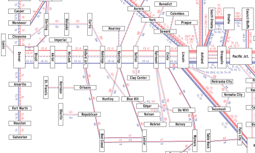
If you want a glimpse of railroad operations six decades ago, this map of the Chicago, Burlington & Quincy provides a window. It’s based on Burlington’s November 1947 freight train operating plan, a chart of schedules furnished to company officers. (Our map was modified to put eastbounds and westbounds on one page and converted to a more schematic presentation.)

Freight service on the Q was tied to two hubs: Galesburg, Ill., for “Lines East” and Lincoln, Neb., for “Lines West” (with the Missouri River serving as the line of demarcation). The train numbers on the map are listed by order of departure from major points. (One caution: Several numbers are used by more than one train.)

The true character of this Granger road lies in its local service. Branchline shipments to ranchers, manufacturers, and farmers in small towns were an essential part of prewar Midwestern life. After World War II, highways would replace many of the branch lines, and later operating plans would not even show the local services that remained.

Railroads included in this map:
Chicago, Burlington & Quincy

Download the map
Success, start your free download!
Download the map PDF
You must login to submit a comment