Geographic growth by acquisition or merger, and the elimination of redundant routes by sale or abandonment, are two factors that have been with American railroading from the outset…and are not about to go away.
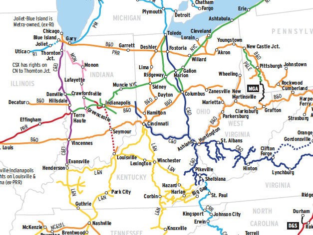
Consider this map of CSX Transportation’s principal ancestors. Shown here are 22 former Class I railroads — in post-World War II terms — plus a handful of short lines. (In 1950, the Interstate Commerce Commission considered a railroad with $1 million or more a year in revenue a Class I.)
There are actually several more Class I railroads that contribute to the current CSX system in small segments around big cities. And if one was to count all the Class I railroads created in post-World War II mergers, such as Seaboard Coast Line, Chessie System, and Conrail, the total would increase yet again.
Note that many of CSX’s current direct routes consist of combinations of railroads that while present historically were often not used as such, because each individual railroad sought the long haul. And, note that many once-sprawling systems, such as Seaboard Air Line, have been chopped into pieces and no longer function as through railroads in the historic sense.
The route-mileage of all the component railroads of today’s CSX in 1956 totaled almost 30,000 miles, whereas CSX in 2012 operated a 21,000-mile system, a 30 percent reduction.
Railroads included in this map:
Amtrak; Atlanta, Birmingham & Coast; Atlanta & West Point; Atlantic Coast Line; Baltimore & Ohio; Buckingham Branch; Canadian National; Canadian Pacific; Charleston & Western Carolina; Chesapeake & Ohio; Chessie System; Chicago & Eastern Illinois; Chicago, Rock Island & Pacific; Clinchfield; Columbia, Newberry & Laurens; Conrail; CSX Transportation; Durham & Southern; Erie; Gainesville Midland; Georgia; Georgia Northern; Grand Trunk Western; Lehigh Valley; Louisville & Nashville; Massachusetts Bay Transportation Authority; Metra; Metro-North Railroad; Monon; Monongahela; Nashville, Chattanooga & St. Louis; New York Central; New York, New Haven & Hartford; Norfolk Southern; Pennsylvania; Pere Marquette; Piedmont & Northern; Pittsburgh & Lake Erie; Reading; Richmond, Fredericksburg & Potomac; Rock Island; Seaboard Air Line; Seaboard Coast Line; Southern; Tri-Rail; Virginia & Carolina Southern; Western Railway of Alabama; Western Maryland


