Railroads & Locomotives Maps Grade profiles of the Pocahontas coal roads

Grade profiles of the Pocahontas coal roads

By Angela Cotey | April 10, 2012

| Last updated on March 16, 2021


Get our weekly newsletter delivered to your inbox

Email Newsletter

Get the newest photos, videos, stories, and more from Trains.com brands. Sign-up for email today!

TM1202

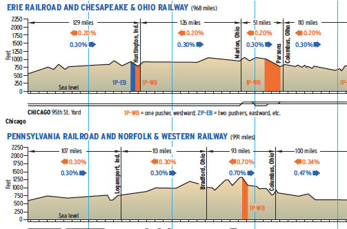
Compared here are the main lines of railroads that, for most of the 20th century, fed the nation with its most important natural resource: bituminous coal mined in Appalachia — the critical ingredient in power plants, steel mills, home furnaces, and factories. In 1927, the year of our comparison, the Chesapeake & Ohio and Norfolk & Western were, respectively, the No. 1 and No. 2 coal haulers; C&O transported 59 million tons of coal that year, and N&W 43 million.

At the center of each system were the mountains of West Virginia. Like a human heart, they pumped the lifeblood of coal to the railroads’ extremities: ports on the Atlantic coast and Lake Erie, and the manufacturing and steel-making hub of Chicago. Both railroads moved coal east to tidewater in Virginia on their own main lines. But to reach Midwestern markets, they relied on other carriers.

Chesapeake & Ohio’s Great Lakes outlet was the Hocking Valley, which had a straight shot from Columbus, Ohio, to the Toledo docks. Access to Chicago was provided by the Erie Railroad, reached at Marion, Ohio, off the Hocking Valley. All three roads were part of the Van Sweringen empire of the 1920s; C&O bought the Hocking Valley in 1930.

Norfolk & Western’s Midwestern coal routes also ended at Columbus, where the Pennsylvania Railroad took over. (Stock purchases from 1900 on gave Pennsy one-third ownership of the N&W). Great Lakes coal traveled PRR’s 111-mile Sandusky Line, which N&W bought in 1960 to link its system with the Nickel Plate and Wabash, a precursor of 1964’s three-way merger.

“Pocahontas” was an ICC rate-setting territory, named for the early Appalachian coal field.

Railroads included in this map:
Chesapeake & Ohio; Erie; Hocking Valley; Norfolk & Western; Pennsylvania

Success, start your free download!
Download the map PDF
You must login to submit a comment