This Map of the Month appeared in the August 2003 issue of Trains magazine.
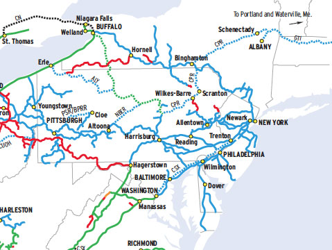
Where does a railroad go? Might seem like the most basic of questions. But with trackage rights and service alliances, a railroad’s franchise — its sphere of influence — may extend far beyond the outermost mile of track it owns. And where today’s mega-railroads go is as much a function of management decision as it is of basic geography.
A glance at Norfolk Southern’s evolutionary system map reveals much — not only about where it goes, but where it might go next. The map shows route expansions and line castoffs since June 1, 1982, when Southern Railway and Norfolk & Western were brought together under holding company Norfolk Southern. (The railroads formally merged in 1990.) Trackage and haulage rights in place before 1982 appear as part of the inherited system, as opposed to agreements negotiated by NS itself, which explains why, for instance, NS appears as a solid line west of St. Thomas, Ont., but dotted east, even though all Ontario trackage is accessed with rights.
Industrial development in the South didn’t create centers that could easily be linked along one corridor. As a result, NS has few “super railroads” that function like UP’s triple-track line across Nebraska. The exceptions are the former Conrail trunk between New York and Chicago, the former Wabash from Detroit to Decatur, Ill., and the CNO&TP between Cincinnati and Chattanooga. Instead, in the Southeast, NS keeps a number of parallel routes linking cities not all that far from each other.
NS likes to hold onto track. Other than Ohio-based Wheeling & Lake Erie, no large regionals have been formed from NS spinoffs. That philosophy changed briefly in 2001, when 500 miles were pared from the network and over 3,000 more were targeted. (NS had 21,500 route-miles in 2003, the time of this map.) Entities like internal short line East Carolina Business Unit, formed in 2002, may be a new alternative to outright disposition. NS also has asked some shippers to help pay for maintenance and improvements on a few light-density branches.
Finally, there are the new agreements — not to mention the Conrail acquisition — that have pushed the outer limits of Norfolk Southern north, south, east, and west.
Railroads included in this map:
Allegheny Valley; BNSF Railway; Buffalo & Pittsburgh; Chicago & North Western; Canadian National; Canadian Pacific; Columbus & Ohio River; CSX Transportation; Florida East Coast; Guilford; Illinois Central Gulf; Kansas City Southern; Nittany & Bald Eagle; Ohio Central; Yankeetown Dock