This Map of the Month appeared in the October 2005 issue of Trains magazine.
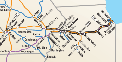
Rock Island Lines serve 14 Western states,” the Chicago, Rock Island & Pacific’s map in the Official Guides of 1964 proudly proclaimed, offering “7,849 miles of modern railroad.” Trouble was, Rock Island’s main lines went everywhere its parallel rivals did, but usually on a longer route and/or one that involved trackage rights in a key big-city terminal. RI’s branch lines already had long felt the pinch of covering too many miles and carrying too little traffic, and most of them probably were no longer “modern.”
Fact was, 1964, the year of the RI chief engineer’s system map below, was Rock Island’s last year of profitability. Merger “saviors” were about to come calling, first Chicago & North Western and later Union Pacific and Southern Pacific. The stodgy Interstate Commerce Commission would muddle along for a decade before it finally approved a UP-SP split of the RI, but by then the Rock Island was in such bad shape that no one wanted it. The decline of its physical plant seemingly was irreversible.
For the moment, though, let’s ignore all that, as well as the fact that the Chicago-headquartered Rock Island had only 16 more years to live. In 1964, the big granger was still trying mightily to hang on to past glory, fielding passenger trains such as the “extra fare” Golden State to Los Angeles with partner SP, the Sam Houston Zephyr on the half-owned Burlington-Rock Island Railroad linking Dallas and Houston, plus six Rockets (Rocky Mountain, Des Moines, Corn Belt, Twin Star, and two Peorias) and a handful of nameless secondary trains. Not to mention a decent-sized Chicago commuter service out to Joliet, Ill., on two lines as far as Blue Island.
But back to the bread and butter: freight. A glance at this map reveals the important lines — those colored other than blue — were the double-track segments across Illinois and in Kansas; the CTC-signaled Golden State path to Kansas City, north-south spine into central Oklahoma, Twin Cities route, and some of the Omaha line; and the several routes protected by automatic block signals.
One problem: The importance of any given line doesn’t always equate with the amount of freight traffic, as revealed by correlating the map with the density chart in the corner. Nevertheless, almost half of RI’s route-mileage is in those three “top-drawer” track categories.
That about three-fourths of the Rock Island’s route-mileage when it shut down in 1980 is still in use in 2005 testifies to the factor of economics ultimately trumping the politics involved in the largest railroad closure in U.S. history.
Railroads included in this map:
Atchison, Topeka & Santa Fe; Chicago & North Western; Chicago, Burlington & Quincy; Chicago Great Western; Chicago, Milwaukee, St. Paul & Pacific; Chicago, Rock Island & Pacific; Davenport, Rock Island & North Western; Galveston Wharves; Houston Belt & Terminal; Kansas City Terminal; Louisiana & Arkansas; Missouri-Kansas-Texas; Missouri Pacific; Northern Pacific; St. Joseph Terminal; St. Louis-San Francisco; Southern Pacific; St. Louis Southwestern; Texas & Pacific; Terminal Railroad Association of St. Louis; Union Pacific


