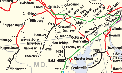
This Map of the Month appeared in the February 2006 issue of Trains magazine.
Mention the Pennsylvania Railroad and iconic images come to mind immediately: passenger trains rocketing down a four-track electrified main line; limiteds scooping water on the fly from track pans; impossibly long coal drags; and mammoth engineering projects, from Horseshoe Curve in the Alleghenies to Louisville’s Ohio River drawbridge, to a maze of elevated freight cutoffs and bypasses.
This map shows what remains of the Pennsylvania Railroad in 2005 compared with the system of 40 years ago. In 1965, the base year of this map, the PRR operated 9,600 miles of railroad and stretched to its historic geographic limits: New York to St. Louis; Mackinaw City, Mich., to Norfolk, Va.
About 4,200 route-miles survive today — just under 44 percent of the ’65 system, and roughly one-third of the 11,709 miles operated in 1925, on the eve of the Pennsy’s 80th birthday.
In October 1964, Norfolk & Western acquired PRR’s line from Columbus to Sandusky, Ohio, to connect with N&W’s new merger partner, the Nickel Plate; although the PRR received trackage rights from Carrothers south, it was the largest loss to the system to date. More line sales and abandonments were to come in the wake of Penn Central, Conrail, and the NS-CSX takeover. Coal branches by the dozens disappeared, as did miles of Midwestern main line. Routes west of Pittsburgh once trod by Pennsy’s Blue Ribbon Fleet of passenger trains were either downgraded or torn up.
Today, 56 different entities use former Pennsylvania Railroad lines. Norfolk Southern operates about half of the surviving route-miles, while fellow Class Is CSX Transportation and Canadian Pacific also lay claim to a few lines. Amtrak owns the passenger-heavy Northeast Corridor and Harrisburg Line. Shortline conglomerates account for 13 operations (two solely on trackage rights), including RailAmerica (with 6 operations), Genesee & Wyoming (2), Anacostia & Pacific (1), OmniTRAX (1), and R. J. Corman (1). Regional operators add another 11, courtesy of the North Shore Railroad System (6), Ohio Central System (3), Carload Express (2), and Black River & Western (2). Rounding out the picture are four transit agencies, two excursion lines (not counting operations crewed by freight railroads), and 22 individual short lines.
Other parts of the Pennsylvania Railroad have been reconstituted as busways, trails, and in a few cases, roads. But it’s a testament to the importance of PRR’s transportation empire that the core of the railroad (the Main Line over the Alleghenies and the Northeast Corridor) lives on.
Railroads included in this map:
Allegheny Valley; Amtrak; Baltimore & Ohio; Buckeye Central Scenic; Belvidere & Delaware River; Buffalo & Pittsburgh; Black River & Western; Canadian Pacific; Central Indiana; Central of Indiana; Central Indiana & Western; Chesapeake & Ohio; Chicago & Eastern Illinois; Chicago, Fort Wayne & Eastern; Columbus & Ohio River; Conrail; CSX Transportation; Delaware Coast Line; East Penn; Eastern Shore; Erie Lackawanna; Everett; Finger Lakes; Illinois Central; Indian Creek; Indiana & Ohio; Indiana Southern; Juniata Valley; Kiski Junction; Lehigh Valley; Logansport & Eel River; Louisville & Indiana; Lycoming Valley; Madison; Maryland & Delaware; Maryland Mass Transit; Michigan Shore; New Jersey Transit; New York Central; Nittany & Bald Eagle; Norfolk Southern; Norfolk & Western; Northern Ohio & Western; North Shore; Oil Creek & Titusville; Ohi-Rail; Ohio Southern; Ontario Midland; Pittsburgh & Ohio Central; Port Authority of Allegheny County; Reading, Blue Mountain & Northern; R.J. Corman; Shamokin Valley; Southeastern Pennsylvania Transportation Authority; Southwest Pennsylvania; Terminal Railroad Association of St. Louis; Toledo, Peoria & Western; Turtle Creek Industrial; Tuscola & Saginaw Bay; Union County Industrial; Walkersville Southern; Western Maryland; Winamac Southern; Winchester & Western; York