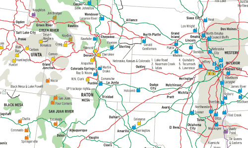
Coal is the No. 1 rail-shipped commodity by tonnage in the U.S., and power plants consume most of it. Three key characteristics shape this map (see June 2002 Trains for the East, and January 2003 for the South): Population is concentrated in cities; most plants are mine-mouth or near the mine; and its most populous state, California, has air-quality regulations that effectively preclude coal-fired power plants within its borders. As a result, rail-hauls of Western coal are dominated by exports, mostly from the Powder River and Uinta Basins to the Midwest and South.
Geography, engineering, and politics shaped this map. The West has plenty of topographic relief and relatively few people and industry, so it was able to satisfy its electrical needs with hydro projects long after the East had to turn to coal. But by the 1960s, suitable sites for hydro projects were used up. Fortunately, high-voltage transmission line and large boiler design by then had greatly advanced, so the West could build big, efficient, coal plants hundreds of miles from cities. Worth noting is that a large percentage of the electricity generated by Western plants is used to pump water long distances, mostly to irrigate fields.
California actually burns coal, just in other states. Southern California Edison, the Los Angeles Department of Water & Power, the California Department of Water Resources, many Los Angeles suburbs, and various irrigation districts own sizeable portions of the Reid Gardner, Intermountain, Four Corners, San Juan, and Cholla plants.
When most of these plants were built, there was some doubt they’d run at capacity for many years. As it turned out, demand grew more than expected while political considerations made it difficult to build more. Most of these plants now are running flat-out, and it’s not quite enough. But global warming has made the future of coal uncertain — natural gas emits 42% less carbon than coal for the same amount of energy. Thus utilities in a deregulated environment are, so far, reluctant to risk building more coal plants. A 1000-megawatt plant, small by Western standards, costs about $1.2 billion at present.
Western coal has had a nice ride in the past 30 years, but where it’s headed now is anyone’s guess.
Railroads included in this map:
Black Mesa & Lake Powell; BNSF Railway; Canadian Pacific; Dakota, Minnesota & Eastern; De Queen & Eastern; Deseret Western; Kansas City Southern; Montana Rail Link; Montana Western; Nebraska, Kansas & Colorado; Union Pacific; Utah


